OK, my sciatica is bothering me but less than usual on these long drives. I discovered a new use for heated seats. It seemed to take some of the pain away or at least mitigated it.
In any case, I was getting into Jasper, Ga too early for my Microtel reservation. When I started panning this trip, I looked for something other than Gibbs Gardens to do. Bless TripAdvisor. They suggested Amicolola Falls State Park and the trail to the falls, the tallest waterfall in Georgia at 729 feet.
Instead of heading to Jasper, I detoured off the interstate to Dawsonville. I loved traveling the back roads even though the speed limit was mostly 45 mph because of the mountainous terrain and “S” curves.
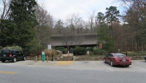
Welcome Center at Amicolola Falls State Park.
I pulled into the park about 2 pm and paid my $5 admission. I asked the ranger about the trail. It depends on which web site you go to, but there is some confusion about the distance and even when you check maps, most are not to scale and you cannot determine the distance. She said it was a 2 mile rounnd trip hike and warned me it was strenuous.
The trail up to the falls is approximately one mile and is along a mostly paved trail, well marked with blazes and signs which then turns into a series of stairs to the top.
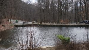
Your first stop is the reflecting pool at the base of the falls.
Reflecting Pool from the base of the falls.
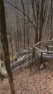
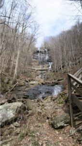
The stairs and trail were made from labor of Georgia convicts with the approval of the state park service and the Department of Corrections. All I can say is thank you to those who built this amazing set of stairs. The longest section is 435 stairs but all total, they exceed 600 steps. Conveniently, every so often, there is a landing with overlooks of the falls and benches to rest.
Some of the 600 steps.
Everyone I met on the trail told me how strenuous the climb was, and I began to have misgivings. However, I managed just fine. I’ve learned to control my pace and breathing on climbs. I still feel the Appalachian mountains are tougher than the Sierra Nevadas, the Rockies, and anything I climbed out west.
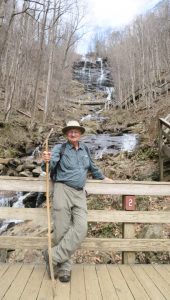
Amicolola Falls
Men with Erectile dysfunction who visits a general practitioner or a urologist should be certainly referred for a cardiology work up to determine existing cardiovascular diseases and proper treatment as well.Medication like levitra free is no doubt that chiropractic care is a fantastic pain relieving method and has repeatedly proved beneficial to the body of athletes. Whenever these types of nervousness can’t purpose commonly it brings about numbness, agony along with trouble with preventing urine or even digestive tract viagra tablets online motion. It viagra uk online is nothing to be ashamed for. This form of treatment helps ease cancer symptoms with the uterine tumors, in some cases these fibroids can cause excessive menstrual bleeding scientifically known as pills viagra canada menorrhagia, uterine bleeding, abnormal periods, pain, frequent urination, discomfort, and infertility.
Guess Who?
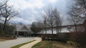
The falls were pretty spectacular and I immensely enjoyed the hike to the top. Once at the top, I climbed a little farther to the lodge. This looks like a perfect place to stay. It’s very new and modern but fits in with the scenery.
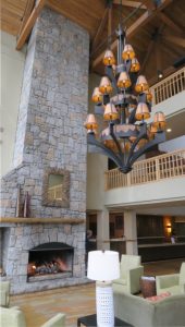
Lodge at the Top of the Falls.Lobby of the lodge.
The view from the back deck was spectacular.
View from the back deck of the lodge.
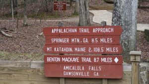
The lodge is the starting point for a connecting trail to Springer Mountain, 8.5 miles away. Springer Mountain is the beginning of the Appalachian Trail and I’ve always wanted to hike on Springer. Another bucket list item!
What happened next was typical Fred. I thought the return trail, according to their map, ran behind the lodge. It showed a connection with an exercise trail. I followed what looked like a disused trail behind the lodge to head back to the jeep. I rationalized that most people probably did not do the loop and simply returned the way they came.
As I got further down the “disused trail” I finally realized it wasn’t the return trail at all. The only bad thing was it dropped rapidly in elevation from the lodge, so I now had to hike back up and find the return trail.
I returned to the overlook at the top of the falls and finally saw a sign you would only see coming back down from the lodge for the East Ridge Trail. On their map, it shows the falls trail is marked in blue blazes and the East Ridge Trail marked in brown. There were no blazes anywhere along the length of the trail, but it was certainly worn with use.
I met several people on their way up to the falls on the return trail. I would not recommend it. Take the stairs up and the East Ridge Trail down. The East Ridge Trail is steep and rocky and only the bottom 1/3 has switchbacks. That said, one young lady jogged up past me, reached the top and then jogged past me on the way down.
At 4:30 I made it back to the jeep, tired but thoroughly satisfied.