3 April 2018
Help! I’m running out of superlatives. I had a great day! I left the motel around 7:45 am and headed straight to Golden Canyon just west of Furnace Creek Visitor Center. It takes about an hour to make the drive and I was on the trail at 9:06 am.
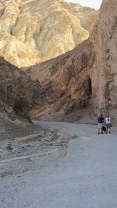
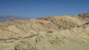
Golden Canyon is considered the most popular trail in the park and I can understand why. It’s called Golden because of the effects of sunrise and sunset on the lightly colored hills forming the canyon. You can hike the canyon and turn around (2 miles round trip) or continue to either Zabrinski Point (no way I was going to hike up there) or finish with Gower’s Gulch. The Golden Canyon/Gower’s Gulch loop is 5 miles. My gps clocked it in as 5.3, but who besides me is counting?
The walk up the canyon is wonderful. There were patches of shade from the surrounding hills and a wind blowing down the canyon. Even though the temperature was climbing into the 80’s the hike was perfect. It’s a steady climb up the canyon and the canyon narrows as you hike upward.
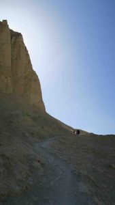
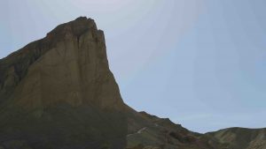
Just before you reach the connection to Gower’s Gulch, the trail takes a sharp upward tract. Up and up and up. At one point, I thought I was standing on top of the world until I realized I was in the shade of a peak that towered over me.
The trail could be a little better marked. As I mentioned in the last post, there were numerous side trails that people had made and unless the park service placed a marker, you were unsure of where the real trail was.
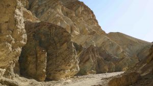
I descended the “top of the world” highpoint and found the connecting trail to Gower’s Gulch. I’ve always wondered what a gulch looked like. Now I know. This gulch is the definitive concept of the word.
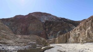
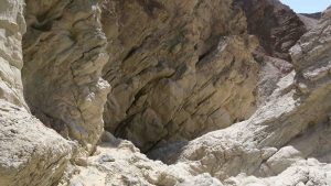
Eventually, the gulch narrows and you have sheer walls on either side of you rising up at least 100 feet. Always on my mind was flash floods. Even though it was a beautiful clear day, I always kept an eye out for where I might be able to make a quick climb to high ground. That’s probably a little paranoid with a beautiful blue sky, but the Boy Scouts always taught me to be prepared.
Later, you have to descend hand over hand down boulders. After a point the gulch levels out and then loops back to the parking lot.
The average hiker walks about 2 1/2 miles per hour (according to Backpacker magazine) and it took me a little over 2 hours to do the loop. For the most part, it was pleasant walking and I highly recommend the hike.
From there, I had my sights set on Titus Canyon Drive. It was recommended to me by a couple I met yesterday. This is a 29 mile (one way for 26 of them) that begins outside the park near Beatty, Nevada. You turn onto a dirt road. A sign warns you that (1) have a full tank of gas [I was half full] and (2) carry plenty of water (3) have a full size spare [I don’t] and (4) have a high clearance vehicle.
It’s a very rough road. Exactly the type of road for which I bought the jeep. At first, it was just a rutted road that shook you to pieces. Then you began to climb ever upward with hairpin curves and nothing to keep you from going over the side. Eventually you reach the top and begin the same type of descent.
There were several places where the road had large boulders embedded in the road with a drop off the other side. The jeep performed like a champion. It has a 4 wheel feature titled “Rocks” and I used that a couple of times. It downshifts into 4 wheel and very slowly allowed me to ease over the rocks as it raises the chassis. Some of the grades were so steep I had to use the “Down Hill” feature of the jeep. Again, great performance. Cars that passed me on the road eventually were parked along side the road and I ended up passing all but one – another jeep.
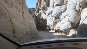
The last 5 miles of one way traffic was through a very deep canyon. In some places, there was room for the jeep but just barely. What an experience to drive through a very narrow canyon with walls extending up hundreds of feet. The entire drive was worth it for the last 5 miles.
I’m a little sad leaving Death Valley. I didn’t know what to expect but I would like a couple of more days to explore this place. The only drawback is this is the second largest national park (Denali in Alaska is larger) and you have to drive an hour to get to most sights. Believe me, it’s worth it.
Tomorrow I head to Ventura, California and hopefully a chance to wash clothes. After one night in Ventura, I catch a boat to the Channel Islands for two nights of camping. I catch the boat back and spend a second night in Ventura and then head for three nights of camping in Pinnacles National Park.