31 May 2018
It was a busy day! I also had one of the highlights of the trip today. More about that later.
Breakfast at The Yellow House has been excellent. They start out with a small bowl of fresh fruit, yogurt, and granola. Then they bring the entree. The first morning it was French toast with orange zest and almonds. Today was a leek frittata with home grown herbs and a great orange/cranberry scone (home made). I may delay my start tomorrow in order to get their breakfast.
My goal was to hit the visitor center before any hiking. That turned out to be a problem. The main highway into and out of town is ME-3 and it’s under construction and one way for part of the way in and no way on the way out. The problem is the visitor center is just off ME-3 and it’s the “you can’t get there from here” story. You have to take alternate roads.
After about 45 minutes, I finally found the correct road, and then found the visitor center. It pretty much was a waste of time. I usually like to get the park map (already had that) and their newsletter which amazingly, is pretty informative. This national park doesn’t produce a newsletter.
Off I went to start my first hike. I decided to try to hike The Bubbles. Both the South Bubble and North Bubble are short hikes (0.5 miles each) and I was wearing the ankle support under my boots, so I thought it would be no trouble. It wasn’t. My ankle held up fine but the problem came when the trail split to each bubble.
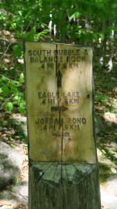
I decided to hike the South Bubble first and then retrace my steps to the split in the trail to the North Bubble.
Once you got to a certain point on the South Bubble trail, it had a sign that indicated “Bubble Rock”. This was pointed out to me on the tour yesterday and I wasn’t interested in seeing the rock again, so I continued on the trail.
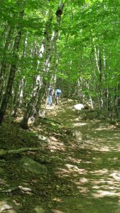
The trail started down to a section described as the Bubble connector. It wasn’t. It was also some of the most difficult downhill I’ve done because it was over a boulder field. Once at the bottom, you were no where near where you thought you’d be. Instead, you were at Jordan Pond.
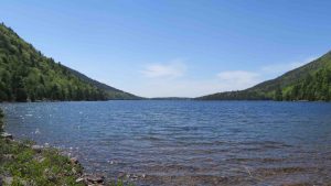
My choice was to either go back up the boulder field or circle around the pond to a short trail back to the parking lot. I opted not to climb the boulder field. After getting back to the jeep, I found I had meandered 2.4 miles. It was beautiful along Jordon Pond with a great breeze.
My next stop took me to the southwestern end of the island to Bass Harbor and Bass Harbor Light. There’s a steep set of steps that lead you down to the water’s edge where you can get a partial view of the light.
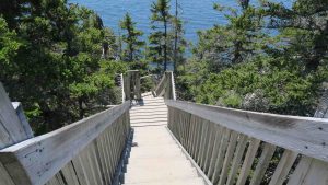
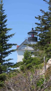
You can then backtrack and walk to the base of the light. As usual, all U.S. Coast Guard lights are now automated. It would have been cool to have been the light keeper with the view of the Atlantic from the lighthouse. This ended up as 0.4 miles.
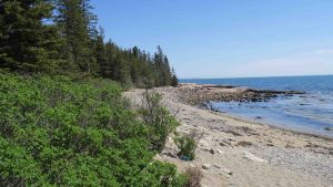
My next stop was Ship Harbor which seems to be an area open to the ocean that some small ship could possibly get into. I think a better name would have been smuggler’s cove. It looks idea for rum running.
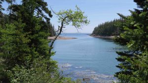
There are some stunning views of the cove and then of the ocean. I clocked in at 2.0 miles on this hike.
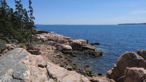
My last stop of the day was the best – and not for the hike. The trail is called Wonder Land and it turned out to be exactly that for me. The loop was 1.5 miles and there is some great coastland but what made this significant for me was I finally, finally got to see a pink lady slipper in bloom.
I have been looking for lady slipper orchids my entire trip along the northern tier of states and had given up hope of seeing one in bloom.
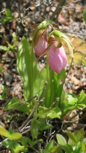
There, on an outcropping (and fenced off by the park service) were several in bloom in an area I would have never expected them. To be honest, the entire trip of 81 days has been worth it for me just for this find . I’ve looked for these orchids for years, as a graduate student, a college professor, and as a hiker these last four years. Finally! Life is good!
Total mileage today was 5.9 miles. My ankle began to act up and I decided to call it a day after the Wonder Land hike. I actually found my way back to Bar Harbor with little difficulty.
Tomorrow I head for Connecticut for one night before I hit Shenandoah National Park!
So glad you found the pink lady slipper in bloom!
I think I remember seeing photos of these when I was in the Boy Scouts and have been hunting them ever since!