Cross Country Tour – Day 35

2 October 2016

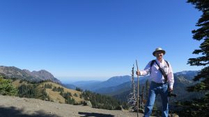
I have hiked a lot in 66 years and I can’t think of a hike I enjoyed more than the one today to Avalanche lake via Avalanche Creek and Avalanche Gorge.  It is considered the most popular hike in Glacier and I can understand why.

Avalanche Creek.
Avalanche Creek.

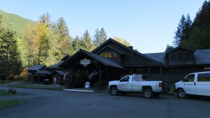
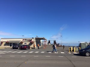
I got going around 8:30 am by defrosting the ice off the car and heading to Whitefish for breakfast at Loula’s right as you get into town on highway 93. It’s in the basement of what looks like an old bank building.  Whitefish is a neat town where the downtown section never died.

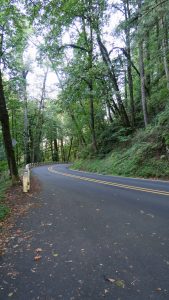
It’s an 18 mile trip to the west entrance of Glacier from Whitefish and then another 12 miles to the Avalanche parking lot.  There weren’t that many cars there at 10:15 am, so I headed out for the Cedars Loop part of the trail which leads to Avalanche Lake.

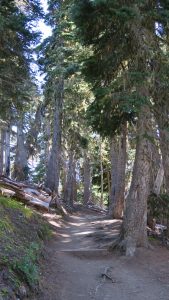
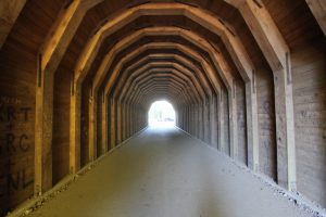
No sooner had I started than I ran into a closed trail sign.  Fortunately, it was only one part of the loop that was closed for renovation and I started at the exit point and walked the boardwalk for the Cedars Loop.  The loop is so named for the huge Western Red Cedars found in this section along Avalanche Creek.  This part of the trail was approximately 0.4 miles and is wheel chair accessible.

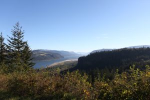
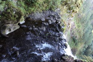
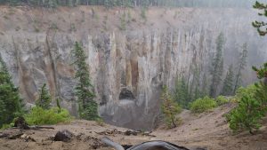
Once you get to the midway point of Cedars loop, you have this wonderful viewpoint of Avalanche Gorge.  It is not a large gorge but the water rushing through is impressive.

Avalanche Gorge.
Avalanche Gorge.

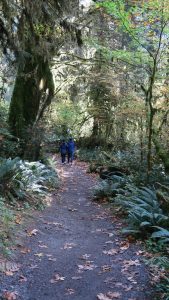
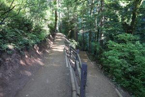
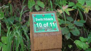
From that point, you can opt to return or continue along the Avalanche Lake trail, approximately 2.0 miles to the lake.  The trail is pretty much uphill from that point on until you drop down on the lake.  The good news is the trail is well designed with manageable switchbacks.  Either that or I am finally getting into shape.

Along the trail to Avalanche Lake.

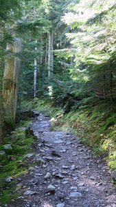
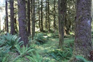
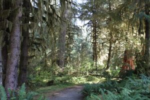
Your pathway is through another temperate rainforest.  This one is actually how I pictured a rainforest to be and the understory was rich in mosses, ferns, lichens, clubmosses, and an olio of other plants.  I was in heaven.

Temperate rainforest along the trail.

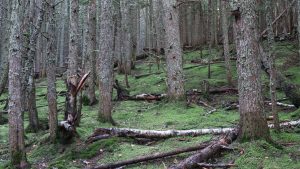
Too many years go, I read a book for young adults (we were called juveniles then) called Freckles by Gene Stratton-Porter. The story is set in the Limberlost Swamps of Indiana where Freckles, who is missing one hand, is hired to protect the tall timber from timber thieves.  He refers to his charges as his cathedral.  That’s akin to how I felt today, walking through nature’s cathedral.

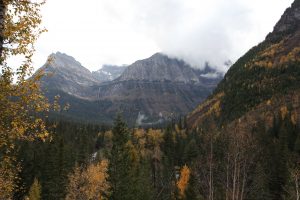
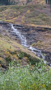
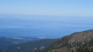
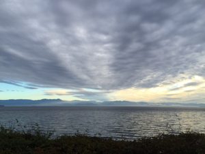
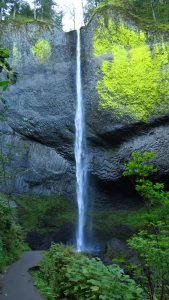
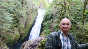
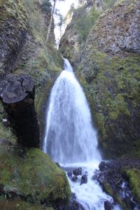
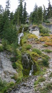
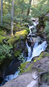
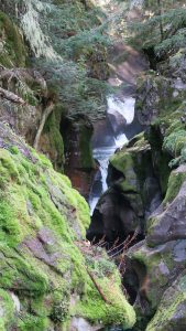
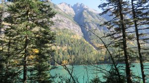
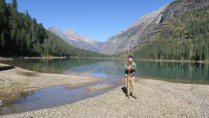
Enough of the religious references! I arrived at the glaciceral lake and it was quite ordinary at the point you exit the trail.  However, if you continue walking around the lake (approximately 0.7 mile) you reach the area of Glacier runoff into the lake. It seems the lake is fed by three waterfalls which you can see of in the distance.  The waterfalls look tiny when you see them but you can hear the roar of water as it comes off the mountain. In reality, the vastness of the mountain diminishes your perception of the waterfalls.

Avalanche Lake from the trail.

I had lunch lakeside (granola-like bar that Holley had given me) and met a couple from Missoula, Montana and another couple from Spokane, Washington.

Avalanche Lake.
Avalanche Lake.

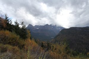
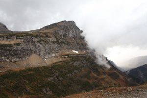
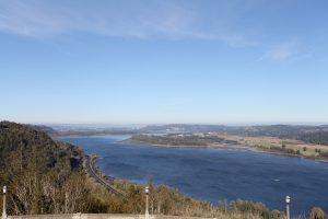
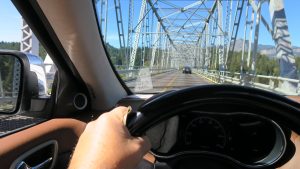
It was then back down the trail, thankfully mostly downhill to the car.  I stopped a couple of other places on the “Going to the Sun” road for photos and then headed back to Whitefish.  I stopped in Columbia Falls for diesel fuel and a car wash.  The jeep looked a sorry state from all the road mud and the layers of bugs that were plastered to the front and windshield.  It took about $6 of quarters to get it cleaner.

I then stopped in Whitefish at a local grocery to purchase Windex, paper towels, and a scrubbing sponge to get off the rest of the stubborn bugs.  I also needed to clean the inside of the windows because there was a film build up that caused a glare when you were heading into the sun.

Dinner tonight was at La Cocina Feliz, a good place for tamales.  Desert was at Sweet Peaks ice cream parlor. I kept the Mexican theme with Mexican dark chocolate which had more than a hint of jalapeño in it.

Tomorrow is a six plus hour drive to Chico Hot Springs in Pray, Montana (again with the religious theme). I’ve stayed here before, January two years ago.  I’ll be sure to dip into the hot springs again.

Cross Country Tour – Day 34

1 October 2016

OK, whatever you doing, stop right now and go online and purchase an airline ticket to Kalispell, Montana and fly in and meet me at Glacier National Park.  Hands down, this is the best national park in the U.S. for scenery.

Enjoy the view!
Enjoy the view!

Every bend in the road (and there a whole lot of them) is more spectacular than the one before.  I’ve never seen such an awesome display of nature, and all I did was drive the “Going to the Sun” road this afternoon. I haven’t hiked one inch yet – that’s for tomorrow. The road is perhaps the most aptly named thing in any of the national parks.  You actually feel like you are heading into the sun.

Clouds rolling in.  Look left, center and you will see a small white, vertical streak. That's actually a pretty good size water fall.
Clouds rolling in. Look left, center and you will see a small white, vertical streak. That’s actually a pretty good size water fall.

I drove in from Whitefish, Montana to West Glacier entrance.  This is the steepest climb of the “Going to the Sun” road as it goes through Logan Pass and the continental divide.  Talk about white knuckles! I think my fingerprints are indelibly etched into the steering wheel of the jeep.  It’s a very narrow road and going up to Logan Pass it is a sheer drop off of several thousand feet!

Guess who?
Guess who?

I was intent on driving the entire length of the road from west entrance to St. Mary campground.  At Logan Pass, elevation 6,647 feet, I stopped for a few photos and I got into a hail storm!

Hail storm arriving.

As I started down the other side, the hail turned to rain and it came down in sheets.  I turned around at St. Mary campground and made my way back.  The entire length of the road is 49 miles, so I drove 98 today holding on tight to the steering wheel.

Waterfalls were everywhere!

The return wasn’t so bad since I was on the inside face of the cliffs.  However, you could tell the people heading up the way I first came were more than a little cautious.

Storm coming through a gap.

If you haven’t been to Glacier, it is a must.  I have no idea as yet what hikes I intend to do tomorrow.  It depends somewhat on the weather, and as I found out today, expect high and low temperatures, sun, rain, hail, and maybe even snow.

Birch trees in all their glory.

Cross Country Tour – Day 33

30 September 2016

The route to Spokane took me back to Port Angeles then along highway 101, and then surprisingly to highway 104 through a really beautiful community called Port Gamble, then to Kingston and then by ferry to Edmonds.  I had not anticipated the ferry and it was a large one – a double decker.  The efficiency of getting cars and transfer trucks on and off is pretty amazing.

I caught a glimpse of the Space Needle while driving through Seattle and I was also surprised at the number of tunnels through Seattle.  Trees are beginning to get their fall foliage so the drive was especially interesting.

The mountains in that area are great and the road system gets you through without any problem.  Then you hit the long, long stretch on the eastern side of the Casades that misses being classified as a desert by less than 2 inches of rainfall a year. Because of irrigation, it is anything but desert-like – quite lush, actually.  I remember reading about labor unrest in this area during the Great Depression which at times got very bloody and brutal.

I did not anticipate the beauty of eastern Washington.  It was worth the long drive and it reminded me somewhat of Montana.

I checked into the Davenport Lusso, a boutique hotel across the street from the historic Davenport of Spokane.  This is probably the biggest hotel room I’ve stayed in this trip and its plush and relatively inexpensive for the night.  It seems I got an up grade in rooms.

img_0456

I had dinner last night across the street in the Davenport’s Palm Court restaurant.  Their claim to fame is Crab Louie, created at the Davenport and named after the owner Louie Davenport.  It was a huge salad with plenty of Dungeness crab. I highly recommend it.  I’ve seen Crab Louie on the menu at other locations but it was nice to have it where it originated.

Today is a drive to Grouse Mountain Lodge outside Glacier National Park.


Cross Country Tour – Day 32

29 September 2016

I woke before sunrise to a herd of deer in front of my cabin. It seems they know a great grazing ground when they see one. They could care less about the guests and only move out of your way when you walk past.

Sunrise at Sol Duc Hot Springs.

Since my room was so late yesterday, they comped me for breakfast and I splurged on a short stack of buttermilk pancakes. I then fired up the jeep and headed to Hoh Rain Forest, some 40 miles away but almost two hours travel time.

Cabin at Sol Duc Hot Springs, Olympic National Forest.

You are constantly entering and leaving the Olympic National Park and you go from 60 mph outside the park to 45 mph within the park, to 35 mph when you enter the Hoh Rain Forest.

I remember reading about a temperate rain forest as a kid and always wondered what it would look like. My imagination was stimulated by an old movie staring Jan Michael Vincent and Chief Dan George called Shadow Hawk that took place in the rain forest will all the ferns and mosses.

Moss Trail At Hoh Rain Forest.

I have to admit I was at first disappointed. It lacked the wow factor of the past few days and then I realized it was a more sedate, sensuous, quiet beauty and I got into it. The air was amazingly fresh smelling, almost to the point of what the ozone you smell after a lightening discharge.

image

Roosevelt Elk are supposedly found grazing within the park but none were seen today. I suspect there were too many people on the trail.

Moss Trail at Hoh Rain Forest, Olympic National Park.

I hiked a couple of trails, ran into some people that wanted to converse, and then had lunch on a picnic table at the park. Sol Duc Hot Springs will provide a “hiker” lunch and that’s what I had. I didn’t eat it all, so as I was getting ready to trash the Saran Wrap, a raven opened the bag and stole a potato chip.

Me and the temperate rain forest.

I decided to continue south along highway 101 and stopped at Ruby Beach and got some great shots of the massive rocks out in the ocean that everyone sees when the Pacific Northwest is portrayed. You could walk right down to the beach, crawl over deadfall, and get up close and personal to the “islands.” It was scene right out of a Chevy commercial!

Ruby Beach.
Ruby Beach.

The drive back took two hours and by then I was ready for dinner. It seems Sol Duc Hot Springs has as a visiting chef, the chef at Bryce Canyon National Park. This guy is great. Last night I had their special, Dungeness crab cakes and cream of broccoli soup. It was outstanding.

Tonight I had to explain to the young lady who was bartending how to make a vodka martini. She thought extra dry meant extra vermouth – ugh! I also had to explain how to make a simple syrup and two people were constantly referring to the bartender’s guide for the drinks. My martini per my instructions was pretty good. The hamburger the chef did for me was great and I would come back here just for his French fries, they were that good.

Tomorrow is a nine plus hour drive to Spokane. I really wanted to do highway 20 and pass through North Cascades National Park and see Grand Coulee dam, but that would put me in excess of 11 hours. I’ll simply have to come back to Washington for those!

Cross Country Tour – Day 31

28 September 2016

Damn! Jim Wilson is right again.  He threatened to have Governor Scott deny me re-entry into Florida if I didn’t go to Hurricane Ridge in Olympic National Park.  He also said something about extradition to Mississippi, so with that hanging over my head, I reluctantly headed to Hurricane Ridge.

As it turns out, the road was a straight shot from the Port Angeles Ferry.  It’s a beautiful drive along a curvy road that took you into sunlight and into shadows.  At one time, the outside temperature dropped 7 F on one curve alone.

Hurricane Ridge, Olympic National Park.

I arrived after a 45 minute drive from the ferry and immediately started on a loop trail. I started the Cirque Rim Trail which is 0.75 miles, got to the overlook and doubl d back on the High Rim Trail (0.5 mile segment) and the hiked to Sunrise Point (0.1 mile).

Trail to Sunrise Point, Olympic National Park.

From Sunrise Point, you could not only we the Olympic Mountain Range but also Port Angeles and, across the Strait of Juan Fuca, Victoria.  Spectacular!  You could see at least 4 glaciers on the mountain tops.

image

I stopped and had lunch on an overlook at an elevation of around 5400 feet.  Lunch was cheese and crackers and water.  I sat next to a lady and her teenage son who lived 2 1/2 hours away and her son had never seen the park.

Near Sunrise Point, Olympic National Park.

Wilson considers this the ultimate in views and I reluctantly agree, but I do want to come home some day.

I think the GPS in the jeep is even getting into the trip.  I programmed both Hurricane Ridge and Sol Duc Hot Springs Resort into the GPS and when I left Hurricane Ridge, the system took me along back roads to Sol Duc.  One road was even a washboard dirt road.  I can’t even remember the last time I drove a washboard road and it brought back fond memories.

I arrived at Sol Doc around 4:30 pm and my room was still not ready.  The resort apparently had some kind of inspection and they were behind.  Sol Doc Hot Springs is noted for, wait for this, hot springs.  There are four areas: one normal temperature 60F, and then three others of increasing temperatures.  I’ll try it once I get settled in the cabin.

Sol Duc Hot Springs, Olympic National Park.

Tomorrow I intend to travel to the Hoh rainforest, another bucket list item. I remember learning about this temperate rainforest in high school and have always wanted to see it.  I hope to bring home some good photos!

Cross Country Tour – Day 30

27 September 2016

I have mixed feelings about Victoria.  It’s a pretty, clean, historic town but the people leave me cold.  Maybe it’s because the climate is so consistent, but there seems to be no emotion to them.  The nicest people I have met so far are the gardeners at Butchart Gardens (I’ve been spelling it wrong all this time) and the cook at the Mexican restaurant down the street from the guest house.

I woke up Florida time, 5:30 am here, and had coffee, checked out who everyone thought won the debate, then showered and shaved for breakfast.

That’s another thing.  Breakfast started at 8:15 am, not 8:00.  Everything in this guest house is very precise.  There’s a note on the door that it locks automatically, a note with glasses there is ice in the dining room, a note in the bathroom not to use the “good” towels to remove make up or you’ll be charged.  I get the feeling that one of the owners is a little bit of a control freak.  Those are just some of the notes in the room.  They are all over the place.

Breakfast was a pleasant surprise (perhaps because the owners subcontract it out).  I had soft scrambled eggs which really were soft scrambled, bacon, toast, fruit, fruit juice, and a complimentary fruit tart along with coffee.

I left after breakfast for Butchart Gardens.  It’s several miles out of town on some back roads and when I drove into the place, I was a little worried about the commercial atmosphere and the ordinariness of the initial view.

My first wow moment was the sunken gardens, produced on the site of an original cement quarry.  It was pretty stunning.

Sunken Garden, Butchart Gardens.

The next part that I really liked was the Japanese garden. I’ve seen many Japanese gardens: San Antonio, San Francisco, Morikami, etc., but this has to be the best and best maintained.

Japanese Garden at Butchart Gardens.

I was pleases to see my birth flower, the Chrysamthemum, in bloom.

Pink Chrysanthemum.
Pink Chrysanthemum.

Another favorite of mine is the Dahlia.

Red Dahlia.
Red Dahlia.

When I used to work in Montana years ago, I was introduced to Fuchsia and they had two types blooming all over the place.

Fushia.
Fuchsia.

I drove back to town (decided not to do lunch or tea at the garden) and drove downtown to see the Empress Hotel.  I walked through the lobby to the sound of the fire alarm which everyone was ignoring and then walked through the dining room and tea room.

The Fairmont Empress Hotel, downtown Victoria.

After that, I took a quick walk around the block and headed back towards the guest house.

British Columbia Parliment Building on the waterfront.
British Columbia Parliament Building on the waterfront.

Before I pulled in, I decided to follow Dallas St. For a ways to see the shoreline.  It’s classified as a scenic way, but I confess the view of the mainland leaves me a little cold.  It looks a little plain and a little rundown.  Perhaps I just don’t like cities.

View of the mainland from the scenic drive along Dallas St.

I returned once more to the guest house and then walked a half mile down Cook Street to have lunch at a Mexican restaurant.  It was some of the best Mexican I’ve had in a while.  Most Florida restaurants can’t decide whether they are Mexican or Cuban and try to do both – poorly.

I have to be at the ferry terminal tomorrow by 9 am, so no breakfast for me.  I’ll spend the night in Olympic National Park at the Sol duc Hot Springs Resort.  I can’t wait to see the rainforest!

Cross Country Tour – Day 29

26 September 2016

It was interesting traveling out of Oregon into Washington.  Even though the scenery is similar, you can still differentiate between the states, if nothing else, by the road quality and speed limits.  The speed limits are slower in Washington and the roads are better in Oregon.

My main concern today and biggest worry of the trip was to make the 1 pm deadline to be in line at the ferry at Port Angeles, Washington to travel to Victoria, British Columbia.  I wanted to build in a little extra time for unforeseen circumstances, so I awoke at 4:30 am this morning and was on the road by 6 am. I pulled into the ferry terminal at 12:30 pm, paid the $126 remainder of my fee for my round trip passage,  had my passport checked, and filled out the passenger card.  I then killed time by walking around Port Angeles a little and catching up on some phone calls.

Black Ball Ferry Terminal, Port Angeles, Washington.

At exactly 1:30 pm, they started loading cars and I was positioned in such a way I was the first off the ferry.  The trip is billed as an hour and a half, but part of that time frame is off loading the cars once in Victoria.  When the customs agent found out I was from Florida, he paid particular attention to my answer I was carrying no firearms.  He then asked if I normally carried guns in my car.  Guess he had been reading about all the gun legislation in Florida.

I made it to the guest house, Dashwood Manor, so named from one of the previous owners.  The “beach” is across the street but it isn’t a real beach. Instead it is riprap to stave off erosion from storms they get from Hawaii. The guest house owner called the storm the Pineapple Express.  Strangely, from 1 pm-4 pm, no one is on staff.  They put a sign on the door they have gone shopping (apparently an everyday thing – or at least an excuse not to deal with guests).

Dashwood Manor, 1 Cook Street, Victoria, British Columbia.


I have to admit the room is quite nice.  It has a king size bed, electric fireplace, a “spa” tub in the bedroom along with a shower in the bathroom.

The Cambridge Room at Dashwood Manor, Victoria, British Columbia.

My room overlooks the beach.  The owner seemed a little reserved but once I paid the charge, he seemed to warm up.   Perhaps it’s just the Victoria way.  Most Canadians are very friendly and outgoing, but I noticed that when I walked to a restaurant for dinner, very few made eye contact with me much less provide any sort of greeting or acknowledgment to my greeting.

View from my window of Strait of Juan de Fuca.

Tomorrow I intend to tour Buchart Gardens, the main reason for my visit to Victoria.  I may try to have tea at the gardens.  Several have recommended I have tea at the Empress Hotel, the oldest and most famed, but the price of their tea is $125 Canadian. Even with the exchange rate, that’s $94 American. Besides, it’s too much food for one person.  I understand the Buchart tea is similar and $35 Canadian and a lot less food.

I may, if I have time, also visit the Abkhazi gardens.  It’s supposedly a short distance from the guest house. Now for some sleep.

Cross Country Tour – Day 28

25 September 2016

For some reason I woke at 5:30 am and was raring to go. However, I had to wait until my room service breakfast was delivered at 7 am.  In any case, I was one the road at 8 am and headed towards Troutdale/Portland on I-84 west.  My idea was to travel old, historic highway 30 as far as possible and see what “old” Oregon looked like.  I exited at Troutdale and started back east on Oregon 30.  If you are ever in this area, I recommend it.  There are a lot of twists and turns and narrow lanes and bridges, but it takes you back to the 40’s and 50’s.  There were a lot of mom and pop inns and restaurants along the way.

Old highway 30.
Old highway 30.

My first stop was at the Portland Women’s Forum State Scenic Viewpoint. I’m not sure why the name other than the obvious but it has some of the best vistas of the Columbia River Gorge along with a view of the Vista House.  To the west of you, Portland, and to the east of you the mighty Columbia River.

Vista from Portland Women's Forum Scenic Viewpoint just off Oregon highway 30.
Vista from Portland Women’s Forum Scenic Viewpoint just off Oregon highway 30.

Next up was Vista House at Crown Point. This is a basalt promitory on the gorge and the building that occupies the site was designed by Edgar M. Lazarus. His detractors referred to it as the world’s most expensive bathroom. Samuel Lancaster supervised the Columbia River Highway project in 1913 and the idea of the Vista House was to promote travel on the highway.  Construction on the house was completed in 1918. It is, of course, much more than bathrooms.  It has an observation deck, a small cafe, gift shop, and exhibits.

Vista House.
Vista House.
Interior of Vista House.
View of Columbia River Gorge from Vista House.

Heading east on 30, the next stop was Latourell Fall.  The hike to see the fall was all downhill and fairly short (0.2) miles.  It’s a spectacular waterfall of approximately 249 feet in height. It’s a straight shot down for the fall whereas most of the falls in the area are tumblers in they have steps down.

Latourell Falls.
Latourell Fall.

Bridal Veil Fall was next.  Most states have a waterfall named bridal veil and they are all fairly broad in appearance.  This was a little further in hiking distance (0.6 miles) but worth the downhill part – which meant all uphill on the return.  Also at Bridal Veil was an interpretive trail with overlooks of the Columbia River Gorge.

Bridal Veil Falls.
Bridal Veil Fall.


The last fall of the day was Wahkeena which was a short hike upward to a bridge spanning the creek in front of the falls.  You were so close to the fall, you got wet from the mist.

Wahkeena Falls.
Wahkeena Fall.

I missed the last two falls on the scenic leg: Oneonta Fall and Horsetail Fall.  I could have seen Oneonta as I stopped at the Oneonta Gorge to view the tunnel carved into the Rock for old highway 30, but did not know the fall was there,  further up the gorge (1.5 mile hike).

Oneonta tunnel at Oneonta Gorge for old highway 30.

Horsetail Fall was so busy, I couldn’t get a parking space anywhere near the place. I opted to head to Bonneville Dam for a tour of the visitor center.

Bonneville Dam - finished in 1938 and still providing electricity to Wahington and Oregon.
Bonneville Dam – finished in 1938 and still providing electricity to Wahington and Oregon.

Bonneville is a large dam and one of the first on the Columbia River. It also has locks to allow ship traffic and barges through.  Since the dam stopped the natural flow when completed in 1938 (F.D.R. Dedicated it in 1937) they installed salmon ladders to allow migration further upstream.  In the visitor center, you can see salmon swimming upstream through specially designed portals in the salmon ladder.

Salmon ladder at Bonneville Dam.

Next, I crossed the Bridge of the Gods into Washingon.  It was built in 1926 and is a 1,856 foot cantilevered bridge across the Columbia River connecting the two states.  There is a toll of $2 in both directions and I assume it goes for the upkeep of the bridge since it was in pretty good shape.  It’s very narrow and as I was returning to Oregon, a transfer truck was beginning to cross, so it is still used commercially.

Driving across the very narrow Bridge of the Gods into Washington.

My last attempted stop was the picturesque town of Hood River.  I say attempted because the downtown area was like the traffic at Multnomah Fall.  I think I found two parking spaces in the entire town and they were far away from the main drag.  With amount Hood close by, it’s a popular stopover for campers, hikers, bikers, and what not.  It looked a lot like parts of Tallahassee to me with a collegiate atmosphere.

Tomorrow, I have to be at the Coho Ferryboat in Port Angeles, Washington by 1 pm for my trip to Victoria, British Columbia.  I have reservations ( not that I knew I needed them, but Keith, who has been to Victoria many times clued me in). It’s about a six hour drive, so I need to be on the road around 6 am to allow me a little leaway in case I hit a traffic jam or something.

Cross Country Tour – Day 27

24 September 2016

I made it!  Goal accomplished!
I made it! Goal accomplished!

OK, I’m officially in a state of nirvana. The ultimate goal of this trip was to see Multnomah Falls in the Columbia River Gorge and I did it.

Many years ago, I saw a photo of this waterfall and decided I wanted to see this.  The photograph was stunning and I did have an idea it could not be as beautiful as portrayed in the photo, but worth the effort to see it in any case.  Boy, is this thing beautiful! More on this later.

I started out a little late this morning.  I woke at 6 am and was on the road by 8 am.  Wouldn’t you know it, it was a blue sky day with perfect temps in the low 30’s. As I drove past The Watchman on my way out of Crater Lake, I had a tremendous urge to stop and do the hike, but I was on a schedule and had already done the hike two years ago.

As I traveled, I kept seeing this snow covered peak.  It finally dawned on me it was Mount Hood.  As I got closer, it got more spectacular.

Mount Hood.
Mount Hood.

In any case, I headed to Columbia River gorge in Hood River, Oregon and checked into the historic Columbia River George Hotel.  What a great place!  My room was not ready (2 pm) so I decided to drive to Multonmah Falls to see what it would be like for tomorrow.

Columbia River Gorge Hotel.

The place was a zoo.  Cars were parked on the sides of the road and there was a back up of traffic forever.  I tried to find a parking place to no avail, so I headed up the road and turned around, thinking of an early start the next day when a parking space opened up.

I did not realize how the falls were so close to the road and there is a restaurant and gift shop as well as a ranger station on the site.  You can walk right up to the scene in everyone’s photos and the sight of the falls was everything I expected.

The photo doesn't do it justice!
The photo doesn’t do it justice!

I decided while there, to walk to the bridge in the photo which was 0.2 miles away and when there decided what-the-hell, climb to the top.  It was a mile in distance, straight up with 11 switchbacks.  I can tell you it was a bit of a climb but I made it surprisingly well.  The traffic on the trail was like Grand Central Station at rush hour.  You needed traffic cops to sort it out.

One of the switchbacks on the trail to the summit.

What they didn’t tell you was the last switch back was downhill quite a ways, which meant a steep climb to the next to the last switchback on the return.  It was worth the effort, worth the trip.  Everything before and since has been icing on the cake.

One of the switchback markers.  This started the downhill part to the falls.  The other 9 were all uphill.
One of the switchback markers. This started the downhill part to the falls. The other 9 were all uphill.

I met a couple from Albuquerque and we got into a friendly banter about the trail, our itinerary, and retirement – he’s wanting to.  Everyone on the trail was super friendly and realized how difficult the climb to the summit was and encouraged everyone along the way.

At the top of the falls looking over the edge.

I returned to the hotel and had dinner there at Simon’s.  This is a great old hotel with an elevator that must be operated by someone at the desk, like I remember as a kid – “3rd floor, men’s”.  I had an outstanding halibut and I’m sorry to admit, 2 martinis – well, not really sorry.

The hotel sits on the banks of the Columbia River, impressive in it’s own right, and my window overlooks the river.  On the wall of the rooms and in the hallways are the prints that I remembered as a kid from my grandparents of the golden age with lovers in swings, languid images of women staring into space, etc.  To me, this was the art of the 1910’s and 1920’s before Art Deco.

My intention is to get up early-ish tomorrow and head back to that area of Multnomah Falls and see other waterfalls along historic highway 30.


Cross Country Tour – Day 26

23 September 2016

There was ice on the jeep when I got up.  I headed to Annie’s Creek Restaurant for breakfast and then, with good intentions, headed to Watchman Peak to hike the 1.6 mile up and back trail. They were repaving the west rim road and I had to be escorted via 1 lane to the pull off.  When I got out of the car, it was 32F with a stiff wind, light rain and you could barely see the summit.  I decided to wait for better weather.

I had to wait again to get back on the west rim road and traveled it until I started the return trip on the east rim road.  There are several great overlooks on the east rim road and I took advantage of Cloudcap Overlook, Phantom Ship Overlook, Sun Notch, and a few unnamed ones.

At Cloudcap Overlook, east rim.

My first “hike” of the day, if you can call it that, was a 0.5 mile loop at Sun Notch to get a great view of Phantom Ship Island.

Phantom Ship Island from Sun Notch, east rim.

Most people know the large island in Crater Lake is Wizard Island, but Phantom Ship (supposedly the pinnacles look like ship masts) is often overlooked.

Wizard Island from west rim.

There are several additional potential islands in the lake if the water level drops which is entirely possible because Crater Lake is formed from rainfall – it is not fed by any springs or rivers.

At Sun Notch, east rim.

One additional stop was Vidae Falls.  All you have to do is pull off the road and it’s there in front of you.  It is a fairly tall fall but not with a tremendous amount of water flow.

Vidae Falls, east rim.

I returned to the cabin for lunch and then tried one more time for The Watchman – a spectacular hike.  Again the road wait but when I got to the pull out, the weather was actually worse.  You couldn’t see the top at all.  I don’t know how the road crews do it but they were laying asphalt in that weather when visibility was about 15 feet.

I decided it was a good day to curl up in bed so I started back to the cabin when Godfrey Glen Trail caught my eye.  It’s found near Mazama Vikkage and it is a 1.0 mile “easy” loop along Munson Creek Canyon. You can hear Duwee Falls as you walk the trail but the canyon is too steep to see the falls.


Munson Creek Canyon on Godfrey Glen Trail.

Tomorrow I set out for Columbia River Gorge to eventually see Multnomah Falls, the prime reason for this trip.  Everything I’ve done so far has been planned around this stop.  I hope for good weather the next day so I can get some good shots.  Then I intend to view numerous other falls and overlooks along the gorge.